

Le cyclone Giovanna se renforce de nouveau à 320 km au Nord de la Réunion
Publié le 12 février 2012 à 21 UTC (17h locales)
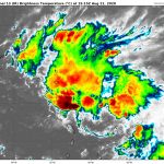
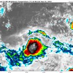
 Figure 1. Image satellite du cyclone Giovanna ce 12/02/2012. Crédit Image : NRL
.
Le cyclone tropical Giovanna de catégorie 3 se renforce de nouveau d’après les images satellites si l’on compare celles de ce matin à celles de cet après-midi, une forte convection s’est développée dans le mur de l’œil. L’œil est mieux défini comme on peut l’observer sur les images satellites et les images radars de la Réunion. La dernière estimation Dvorak est de 6.0 à 17h30 UTC. Si cette tendance se poursuit, il est probable, que les prévisions d’intensité à court terme soient revues à la hausse. Le système est maintenant soumis à l’influence d’une dorsale de moyenne altitude qui s’est rétablie au Sud, ce qui devrait permette au système de s’orienter progressivement vers l’Ouest ces prochains jours.
À compter du lundi Giovanna devrait subir un cisaillement vertical du vent faible à modérée du côté Nord au niveau de la dorsale. Un affaiblissement du système est probable avant qu’il n’atteigne la côte Est de Madagascar lundi soir entre le Nord de Fenerive jusqu’au Sud de Mahanoro, y compris la ville de Tamatave.
Les habitants des îles Mascareignes et de la côte Est de Madagascar (en particuliers les gens qui résident dans la zone menacée citées précédemment) sont invités à suivre de près l’évolution du système.
.
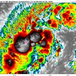
 Figure 2. Image infra-rouge et trajectoire prévu du cyclone Giovanna. Crédit Image : CIMSS
.
Giovanna était situé à 18h00 UTC par 18.0 Sud et 55.6 Est, soit à 320 km au Nord de la Réunion qui est en pré-alerte cyclonique, il se déplace vers l’Ouest-Sud-Ouest à 22 km/h. La Réunion est également en vigilance forte houle (voir Météo France Réunion). Giovanna a des vents soutenus moyens de 100 kts soit 185 km/h et des rafales de 125 kts soit 230 km/h, sa pression au centre était estimée à 962 mb.
*******************
Administrateur de Chasseurs de Cyclones
 Chasseurs de Cyclones sur Facebook
 CYCLONE EXTREME
 METEODESILES-METEODESCYCLONES
 Ouragans.com
 SXMINFO
 TROPIKFM SBH
 VOLCREOLE.COM
Seychelles Meteorological Services
Tropical Cyclone Advisory #16
CYCLONE TROPICAL INTENSE GIOVANNA (09-20112012)
4:00 AM RET February 13 2012
================================
At 0:00 AM UTC, Intense Tropical Cyclone Giovanna (937 hPa) located at 18.2S 54.0E has 10 minute sustained winds of 100 knots with gusts of 140 knots. The cyclone is reported as moving west at 12 knots.
Hurricane Force Winds
========================
50 NM radius from the center
Storm Force Winds
=================
70 NM radius from the center
Gale Force Winds
=================
90 NM radius from the center extending up to 110 NM in the southeastern quadrant and up to 140 NM in the southwestern quadrant
Near Gale Force Winds
=====================
120 NM radius from the center, extending up to 150 NM in the southeastern quadrant and up to 175 NM in the southwestern quadrant
Dvorak Intensity: T5.0/5.0/D0.5/6 HRS
Forecast and Intensity
========================
12 HRS: 18.6S 51.4E – 90 knots (Cyclone Tropical Intense)
24 HRS: 19.0S 48.9E – 80 knots (Cyclone Tropical)
48 HRS: 21.4S 43.2E – 25 knots (Perturbation Tropicale)
72 HRS: 23.1S 39.9E – 35 knots (Tempête Tropicale Modérée)
Additional Information
=====================
Giovanna intensified over the last 6 hours with satellite presentation at 6.5 for a few hours. 6 hourly and 3 hourly averaged DT are both at 6.2 and the presentation is slightly deteriorated since 2330z. Current estimation of both mean sea level pressure and vortex max are in excellent agreement with the good AMSU (n19) intensity estimate of 2151z with a mean sea level pressure at 938 hPa and max wind at 113 kt (1 min mean) Latest radar imagery suggest that a new eyewall replacement cycle is occurring (to be confirmed with micorwave imagery)
System is now undergoing the steering influence of the mi-level ridge rebuilding in its south. This deep mid-level ridge would steer the system on a westwards to wast southwestwards track today and then southwestwards Tuesday as the the mid-level ridge shifts to the southeast of the cyclone.
Later this afternoon, Giovanna should undergo stronger easterly vertical wind shear on the northern side of rebuilding upper level high pressures. The impact of this increase with a shear that is in the same direction than the cyclone motion is difficult to appreciate for a system like Giovanna with a self-induced outflow … However it is likely that some weakening could occur before the landfall on the eastern coast of Madagascar tonight.
1 year day to day after the landfall of TC Bingiza over the Masaola area, the eastern coast of Madagascar will experience a new cyclone!! The expected landfall remains located between Fenerive northward to Mahanoro southward including the city of Tamatave. It is worth noting that the latest ECMWF outputs within the last 36 hours target the area between Tamatave and Vatomandry.
Weather conditions are expected to worsen rapidly today within the potential landfall area. All inhabitants are invited to closely follow the closing of this dangerous cyclone.
Giovanna should be back over waters of the Mozambique Channel Wednesday within a rather favorable atmospheric environment with a decreasing easterly shear as the system will move closer to an upper level ridge. However Thursday and Friday and according to ocean heat content map from the Colorado university, the system could encounter rather limited heat potential waters south of 22S and west of 40E. Moreover the system is expected to move little by that time (new barometric col situation). According to latest numerical guidance that suggest again some strengthening, the forecast intensity is more aggressive than previously.
The next tropical cyclone advisory on TC GIOVANNA issued by Seychelles Meteorological Services will be issued at 6:30 AM UTC..